race preview

Marathon 10: race preview

Tomorrow I’ll be running marathon number 10! It is the last one in Canberra and will be a mix of official race and my own made up course. I’ll start at 7:30 with the Weston Creek Half Marathon (WCHM) that goes from the Black Mountain peninsula down to Phillip and back (see map below). After the WCHM I’ll get my backpack and follow the race course once again just continuing a bit further to pay a visit to The Runners Shop. I want to pass by and thank them for the pair of On Cloud shoes that will be given to a lucky supporter after marathon 11 (check the details of the prize draw in my previous post).

Screen Shot 2016-03-19 at 11.07.09 AM

Course map. Click here for an interactive version and .gpx file

Screen Shot 2016-03-19 at 11.06.21 AM

Elevation profile. Red Hill is going to be interesting.

From there I’ll head northeast, climb Red Hill and pass by the Parliament House before reaching Lake Burley Griffin for the last 1.5 km. I’ll finish in Kingston, more precisely in front of Brodburger where I’ll have a well deserved after-marathon burger.

This time I’ll have the company of Matthew Geleta for the whole marathon. Matt is doing his own fundraising event to help provide education to Ebola orphans in West Africa. He is running 2000km in 20 weeks finishing with a marathon in Sierra Leone. It will be a pleasure to share the roads and trails with him tomorrow. I’ll also have the company of Ethan and Ruvi for the last 10km. These guys will bravely face the steepest part of the race.

If you want to run with us, you’re more than welcome. If not, join us for burgers afterwards. We are expecting to arrive between 11:30 and 12:00. I’ll be using the real-time tracking app again. I hope this time it will work properly.

Don’t forget Give $10 for 10 and go into the draw for the pair of Cloud shoes from On.


Advertisement

Knee testing and course familiarisation

The past few days were marked by planning the marathon day, going easy with my knee, and jet lag. Today(*) I was up at 2:30 am and after failing miserably to get back to sleep, I decided that the knee had had enough break and it was time for it to be tested. So, I jumped out of bed and went for an early (5 am) run around the Rodrigo de Freitas lagoon. Two laps with a progressive increase in pace was my plan and that’s what I achieved:

training

Loops around the lagoon and 1 km split times. Red arrow indicates the road leading to the nasty climb for the third marathon (see photo below).

It was the first run over 10 km since the second marathon a few weeks ago and I was quite happy with the run. The knee is still a bit uncomfortable but I managed my pace well and was able to run fast even after a decent distance. This gave me extra confidence that the knee will be able to cope with the challenging course that I have set for marathon 3.

A few hours after the run and the knee pain came back. Not severe but annoying enough to make me want to check the hardest part of the planned course by car. It was also a great opportunity to show Joe, a friend from work, great views from Rio. As soon as we started the ascent and the forest begun to dominate the surroundings, I was sure that I have made the right decision about the course. I felt so good already! Not even this sign that we found on the side of the road would made me change my mind:

placa

Information sign just in front of the Vista Chinesa. The feeling of running surrounded by the forest certainly surpass any fear of hills (I say this now…).

I can’t wait to run up there on Sunday!

(*) the post was written on Monday but due to a problem with the internet at the hotel I could only post it today.

Marathon 3: preview

One week to the third marathon and it is time again to write a post with the race preview. I’m jet-lagged in a hotel room in my home town, Rio de Janeiro, Brazil. My last work trip this year and my last chance to run a marathon overseas. My goal of coming up with a course full of challenges and beautiful views was made easy by this blessed city that is Rio. So here is my first draft of the marathon course:

image

Planned course (in red) and elevation profile at the bottom. In blue there is part of the road cycling course of the event in preparation for the 2016 Olympic Games in Rio.

I’ll start at the Museum of Modern Art and finish at the top of the Corcovado, the most iconic landmark in the city. To get there, I’ll run together with my friend Joe on the bike path along Aterro do Flamengo and Botafogo beach before reaching the base of the Sugar Loaf cable car. There, we’ll meet my sister. From there the three of us will run towards the famous beaches of Copacabana and Ipanema and then make at turn to run half of the loop around the Rodrigo de Freitas Lagoon. Somewhere around the Lagoon, Joe and Debbie will stop and I’ll be by myself to start my big climb towards the Christ the Redeemer statue through the roads of the Tijuca Forest, the largest urban forest in the world. On my way I’ll pass by the building of the Institute of Pure and Applied Mathematics (IMPA) (home of Brazilian’s Fields Medalist Artur Avila), Mesa do Imperador (Emperor’s Table) and Vista Chinesa (Chinese Outlook) before reaching the top of the Corcovado mountain. I’m really looking forward to this run!

Since I came up with this astonishing course, some things happened. First, my knee injury. Even though I’m confident that I can get through the marathon, depending on how my knee reacts to the medium distance run that I have planned for the week before the marathon, I may be forced to reconsider the climb to the Corcovado. The second issue is that Rio is going through test events for the Olympic Games and my route has a considerable overlap with the road cycling event on 16 August (see the blue course in the map above). I have to check whether there will be road closures enforced, otherwise I may appear on TV running side by side with top cyclists as those crazy spectators on Tour de France.

If you’re interested in joining me at any part of the course just send me a message. As in marathon 2, I’ll post a link on the race day with my current position so that people can find me and join at any point. The more the merrier!

Ah, and don’t forget to make your donation for cancer research!

Airplane post: marathon #1 preview

Yesterday I left Canberra on my way to a workshop in Benasque, a small Spanish village at the Pyrenees. In the past 24 hours I have watched three movies, read a book, worked on a grant proposal rejoinder, eaten four airplane meals, and slept for a few hours. The problem? I’m still in an airplane!

I also watched a couple of sports documentaries: one about the 2015 Dubai marathon, and another about the Austrian cyclist Gerhard Gulewicz and his breathtaking attempts to win the Race Across America (RAAM). This reminded me that I have an extra reason, besides science, to be excited about this workshop. As you may have read in this post, Benasque is the place I chose to run the first marathon of my fundraising challenge. Since I have some time to spare before I’m asked “lamb or chicken” and before we land in Barcelona, I thought it was a good time to write a marathon preview.

I always knew that planning a marathon in Benasque would be challenging. There is no way to avoid the mountains. Of course you can limit the amount of climb by designing a course with multiple laps along a less hilly loop, but that would be no fun, would it? I studied some maps from the Wikiloc website and used my previous limited knowledge of the region to design a course. I was tempted to go to the lakes that I showed here, but that would involve some steep hiking over rocks rather than running, so I ditched it. Instead, I went with this* (similar to what I described here):

benasque_map

Course map for the first marathon. You can find the details at: http://www.mapmyrun.com/routes/fullscreen/747602475/

Screen Shot 2015-06-21 at 8.09.34 pm

You certainly noticed the long way up, 1650 m of elevation gain, with two category 1 and one category 5 climbs. Sounds very hard but you know what they say: the more impressive your challenge, the better your chances of a successful fundraising. You may have also noticed the ridiculous maze-like beginning, included just to reach the marathon distance. ‘Why not extend the course one more kilometer from the final point?’ – you may ask. Well, that final point was meticulously planned to be the highest point of that track. If I went a few hundred meters further, then I’d have a steep descent that would need to be climbed back. No, I didn’t want to make it any harder than already is.

To be honest, I don’t really know whether I can run that last bit or not. I’ve been on a bike for most of that course before, but the last climb from kilometer 18 to half-marathon mark is unknown to me. I guess I’ll have to check that on the day. I can always make up for the distance by running past Benasque and then coming back. But anyone that has had the chance to race in a course that you pass in front of the finishing line and still having a few kilometers to run knows that it is no fun.

By the way, I went for the lamb! 😉

* Since I published this post the course has been changed to make it easier for people to run parts of the marathon with me. The final map can be found here.

Marathon #1 location unveilled

It took me only three weeks, from the moment I had the idea of running twelve marathons in a year, to write my first post on this blog. It was just the time to tell my wife about it, having my mental sanity questioned by the family, and getting their green light. Shortly after, I was being pushed, I mean encouraged, to write a blog about it (my wife is a journalist… 😉 ).

As you can imagine, there hasn’t been much planning put into it. But I haven’t been too worried about it because in April, after a five years hiatus, I finished my third marathon at the Australian Running Festival, beating my PB by almost 15 min.! I also raced the whole ACT triathlon summer series and have been consistently training with the Bilbys  (I’m a proud member of the Canberra Bilbys Triathlon Club and was through their novice program that I became a triathlete). So, I’m not starting from scratch but it is about time to start planning at least the first few events.

As I mentioned in the FAQ, I’m not going to be traveling around running official marathons, but will select a few events and fill in the gaps with runs measured by my GPS watch. However, I will be traveling for work in the next few months so I thought: “Why not run some of the marathons while I’m away attending conferences and workshops?” Well, the first destination is… Benasque, Spain!

Screen Shot 2015-06-08 at 9.31.37 pm

On my way to the Portillon de Benasque in 2011.

Screen Shot 2015-06-08 at 9.33.06 pm

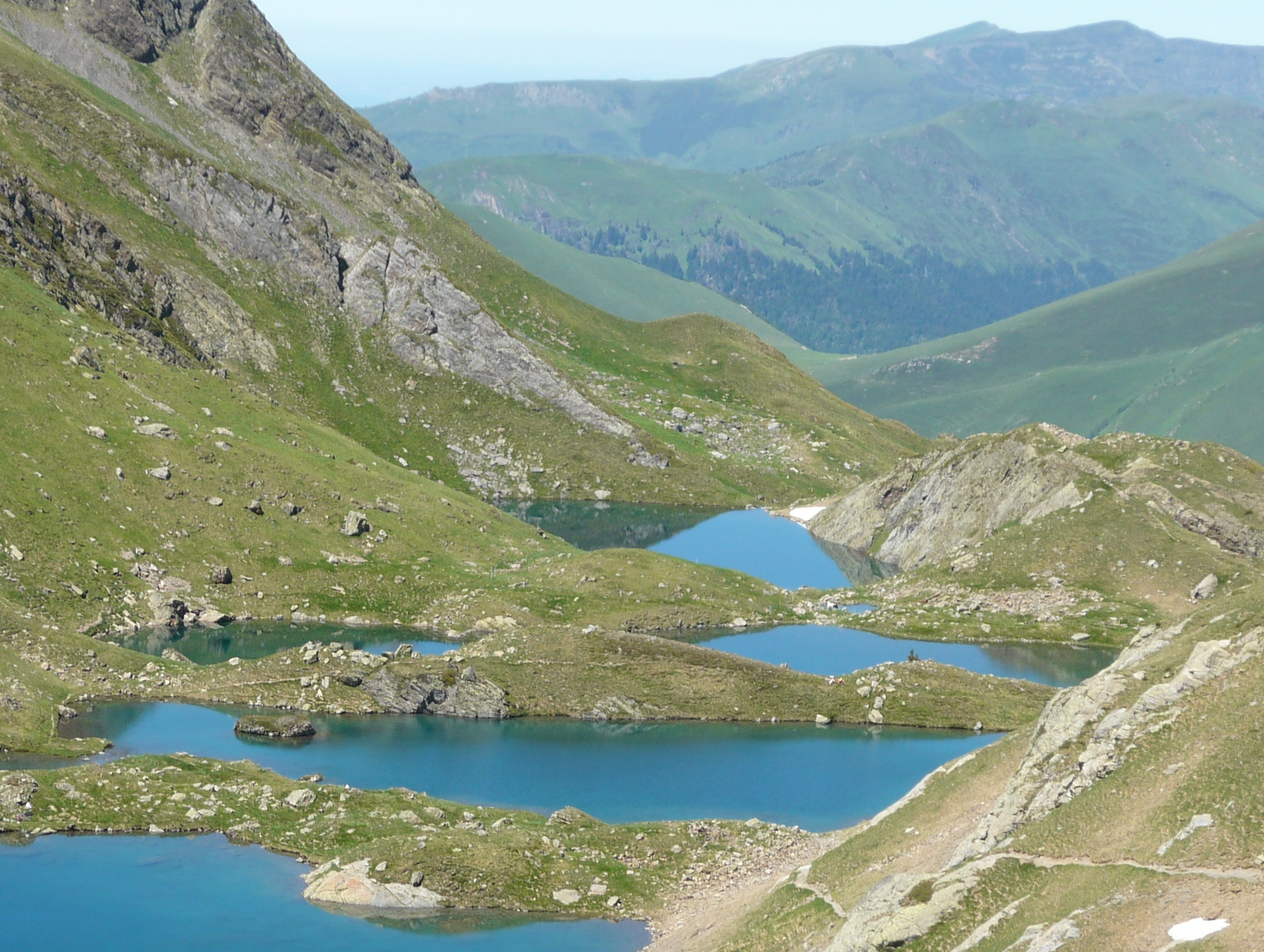
View from the lakes on the French side of the Pyrenees.

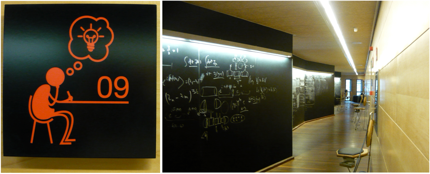
I’ve been to Benasque a couple of times, in 2011 and 2013, for this biennial workshop on quantum information. The “Centro de Ciencias de Benasque Pedro Pascual” is the perfect place to do science: great people with similar scientific interests put together in a welcoming building with blackboards along the corridors and internet access. All that a theoretical physicist needs 🙂 !

benasque_work

I have an idea! How about combining work and my marathon challenge?

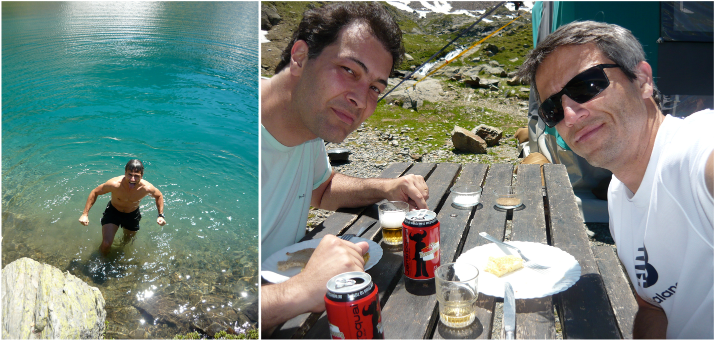
On top of that, the little village lies at the Spanish side of the Pyrenees and offer amazing options for those interested in outdoor activities in the free time. In 2011, we hiked to the French side passing the Portillon de Benasque. After a quick “swim” at the freezing lake we went to the little Refuge de Vénasque to grab some food and beer!

benasque_2011

In 2011, my friend Terra Cunha and I hiked to the French side of the Pyrenees. The swim in the freezing water was a shock! But we were rewarded with beer and food at this little place by the lakes afterwards.

In 2013, it was the turn of Ruynet, my PhD co-supervisor back in 2002, to join me on a mountain bike ride from Benasque to the Hotel Spa Hospital de Benasque. Nothing technical, just a long ride with a “few” climbs. Even longer with our bad navigation, wrong turns, a flat tire, and stops for photos, or simply enjoy the view. Having ridden for almost 5 hours to reach our destination, we devoured the sandwiches we had prepared earlier and quenched our thirst with the cold beer served at the little shack.

benasque 2013

One of the stops to contemplate the view on the long ride to the Hospital de Benasque.

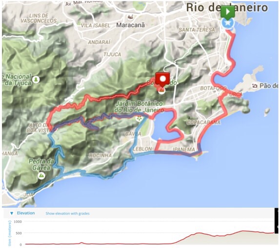
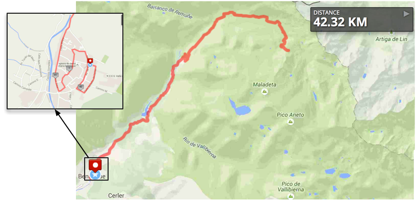
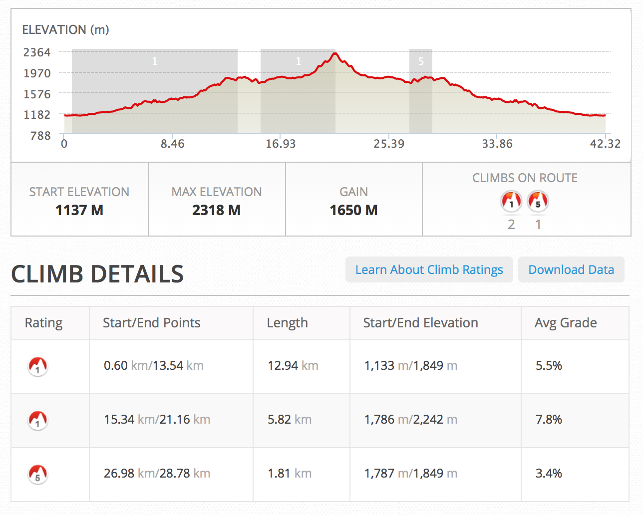
In 2015 the plan is to fill part of the free weekend with the marathon (check the events calendar for the dates). The final route hasn’t been decided yet but I have some ideas. I found this website called Wikiloc that has lots of trails and mountain biking routes in that region. At the moment, I’m tempted to start my marathon challenge in style! The idea is to start along the same mountain bike course we did in 2013 but adapting it to fit the marathon distance. It would be something similar to this map. If I choose this route, it will be a though first half climbing all the way from an altitude of 1150 m to almost 2300 m. The advantage is that the second half will be a breeze. A negative split is almost guaranteed! If you know of a good route around that region, please let me know. I’m open to suggestions!

Here is the link to some of the activities I did there in 2013:

Benasque to Cerler (9 km)
Benasque to Cerler 2 (9 km)
Ride to La Besurta (Hospital de Benasque)  — many stops, wrong turns… (25 km).
Ride back from La Besurta (Hospital de Benasque) — mostly along the road (16 km).
Benasque to Linsoles (12.5 km)
Beyond Cerler — That was a good one! (20 km)